What is a Local Roadway Safety Plan (LRSP)?
A Local Roadway Safety Plan (LRSP) provides a framework for analyzing, identifying, and prioritizing roadway safety improvements to reduce severe injury and fatal collisions on local roadways. The LRSP supports a holistic approach to addressing road safety for all road users and also contributes to the California Strategic Highway Safety Plan (SHSP), which aims to reduce traffic fatalities and serious injuries across the State’s roadways.
Why is an LRSP important?
Development of a LRSP will help San Mateo County get funding to build roadway improvements that will positively impact everyone residing in and traveling through San Mateo County, especially the most vulnerable communities.
Project Details
C/CAG has developed a Countywide Local Roadway Safety Plan to improve motorist, bicyclist and pedestrian safety on local streets and roads throughout San Mateo County. This plan was developed after hearing robust input from the community and using data collected on traffic patterns and incidents. The final Countywide Local Roadway Safety Plan was formally adopted by the C/CAG Board on June 13, 2024.
The approved Jurisdiction Specific Chapters are listed below. Jurisdictions that are not listed either have their own plan or one that is underway.
| Atherton Chapter | Foster City Chapter |
| Belmont Chapter | Hillsborough Chapter |
| Brisbane Chapter | Half Moon Bay Chapter |
| Colma Chapter | San Carlos Chapter |
| East Palo Alto Chapter | Woodside Chapter |
Countywide Local Roadway Safety Plan (LRSP) Addendum (April 2026)
C/CAG completed an addendum to the Countywide Local Roadway Safety Plan (LRSP) to provide additional context and detail for key actions identified in the plan. These areas include Strategy and Project Selection, which explains how projects and strategies were identified, prioritized, and scheduled for implementation, and Progress and Transparency, which describes how C/CAG will monitor and report on outcomes over time. The Technical Memorandum is available for review.
Background on Completed LRSP and Outreach Efforts (2024)
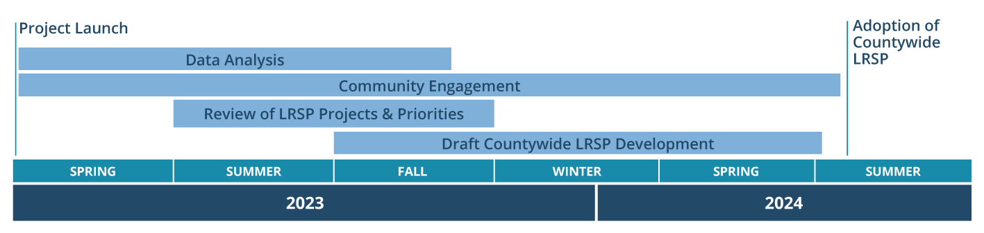
Project Timeline of LRSP (Click to Enlarge)
Public Outreach
The Countywide Local Roadway Safety Plan could not happen without extensive community input and participation – thank you to all who provided feedback and contributed to the development of this plan!
This project had multiple phases of outreach, where the project team heard from local communities on the specific locations and road safety priorities that concerned them, solicited input on priority locations for safety improvements and collected feedback on potential countermeasures to reduce fatalities and serious injuries. The project’s extensive outreach efforts are outlined below:
Draft Plan Presentations
The project team presented the public draft plan at the following meetings:
- C/CAG Congestion Management Program Technical Advisory Committee Meeting – 1:15pm on 3/21/24
- C/CAG Congestion Management and Environmental Quality Committee Meeting – 3pm on 3/25/24
- C/CAG Bicycle and Pedestrian Advisory Committee Meeting – 6:30pm on 3/28/24
- C/CAG Board of Directors – 6:30pm on 4/11/24
Phase 2 Outreach
Phase 2 outreach solicited community input on these draft priority location maps, which were developed using data collected on traffic patterns and incidents and finalized after receiving input from respective communities and other stakeholders. Final maps may be different from draft versions. Please note some jurisdictions (10 out of 21) already have an existing or concurrently developing their own safety plan and do not have identified locations as part of this work.
- Atherton
- Belmont
- Brisbane
- Colma
- East Palo Alto
- Foster City
- Hillsborough
- Half Moon Bay
- Portola Valley
- San Carlos
- Woodside
Past Outreach
If you missed the Phase I webinar, you can view the recording by clicking on the “Countywide Virtual Kick-Off Meeting” link in the table below or view the presentation located in the resources section: “LRSP Community Meeting” link.
Past Events
| Events/Meetings | Date |
| Countywide Virtual Kick-off Meeting (Click for recording) | Thursday, August 10 at 6pm |
| East Palo Alto Farmers Market | Wednesday, August 16 from 8:30am- 1:30pm |
| Half Moon Bay Farmers Market | Saturday, August 19, 9am-1pm |
| Foster City Summer Days | Sunday, August 20, 11am-5pm |
| San Carlos Block Party | Sunday, August 27, 4-8pm |
| Belmont Farmers’ Market | Sunday, December 17, 2023, 9am-1pm |
| Woodside Public Library | Wednesday, December 20, 2023, 3-7pm |
| Colma BART Station | Tuesday, January 9, 2024, 9am-1pm |
| Atherton Library | Tuesday, January 16, 2024, 3-7pm |
| Brisbane Farmer’s Market | Thursday, January 18, 2024, 2-6pm |
Project Resources
To learn more about the Local Roadway Safety Plan, see below for additional resources.
As the Countywide Local Roadway Safety Plan is now completed and approved by the C/CAG Board, we want to thank the communities for providing valuable input in each phase. Your input was vital to developing a comprehensive countywide plan and we look forward to sharing plan adoption updates via this project webpage.
For questions about the project, please reach out directly to project staff at: jlacap@smcgov.org or egaye@smcgov.org.